Gorredijk Churchyard on the Kerkewal
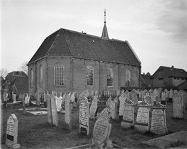
The Reformed church of Gorredijk was built in 1683 and was under a joint church guardianship with Kortezwaag until 1698. The churchyard on the Kerkewal in Gorredijk used to be located within the Gorredijk entrenchment. Around 1830, the plot covered some 2,370 m². The church and churchyard were accessible via a path that ran from the Kerkewal.

In 1818 there were around 30 graves in the church and 194 in the churchyard. Not much is known about the use of the churchyard in the nineteenth century. However, the church wardens did make an appeal in 1864 to the owners of graves to come forward. Those who did not do so lost the property. A similar appeal was made in 1897. Perhaps there was a lack of space and they were trying to make room. In 1920, the municipality received a request from "De Laatste Eer" to establish a new cemetery as soon as possible. The town council discussed the possibilities for this in 1924. In 1926 the new cemetery on the Hegedyk was put into use and from then on the Kerkewal became less in use. As early as 1929 there was talk of closing the cemetery, but closure was still decades away. The last burial was in 1966.
Beginning in 1972, there were discussions between the congregation and churchwardens about taking over the church and churchyard. In 1975, the church trustees requested that the churchyard be closed retroactively. In 1971 the church building became a national monument because of the pulpit, and the gable stones. The church was demolished in 1985 for its dilapidated condition. A few gable stones remain bricked into the remnant of the front facade. Another part of the facing stones has been given a place in the Ontmoetingskerk of Gorredijk on the Schansburg.
Municipality of Opsterland became the owner of the churchyard in 1985. The church guardianship could not afford to repair the church, nor was there any reason to keep the church any longer. The municipality bought the land from the church guardianship for 13,000 guilders and exactly this amount the church guardianship paid back to the municipality as compensation for the maintenance costs of the churchyard. The church guardianship also paid for the demolition. The congregation's plan was to use the land as a park.
In the 1990s, problems arose in the cemetery due to neglect and vandalism. An inventory was conducted at that time. In 1997, research was conducted into options for clearing the graves and dissolving the cemetery. Several other stakeholders, such as Local Interest, were then concerned about the continued existence of the cemetery. Some dilapidated graves were removed and a beech hedge was planted around the site. The floor that lay within the old foundations was repaved.
Location in the landscape
Until World War II, church and cemetery were at the edge of the development. The back was still pasture land. Along Main Street there was more and more construction, whose gardens bordered the church's plot. Along Kerkewal there had been a row of dense buildings since the seventeenth century; their gardens were also adjacent to the church property. After 1945, new houses were built on the north and northwest sides and new streets were constructed: the Jan Eisingastrjitte and the Loaijerstrjitte. A corner that remained open was also built up in the 1990s, so that the site was completely surrounded by buildings.
The site is named in the Gorredijk Kom zoning plan as zoned "Cemetery" and is surrounded by the properties on Main Street zoned "Center" and dwellings zoned "Residential."
Construction and green aspects
The cemetery used to have few green elements. Old photos show that it was an area without a green border as it is today. After 1985, the landscaping changed little. Along the path leading to the cemetery from Kerkewal is a mixed hedge. At its end is a lime tree to the right of the foundations. A conifer also used to stand here. Some ash trees have also disappeared due to disease. Around the site there is a lot of greenery. The site itself consists of grass, there are no paths present between the graves. The fence is formed by a beech hedge, interrupted at the back by a rampart, which depicts a part of the old rampart (schans) of Gorredijk. In a few places, the grave monuments are surrounded by shot greenery. Some of the wall remnants are also overgrown with ivy and other plants.
Typology of grave monuments
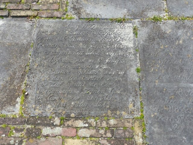
A special part of the churchyard are the preserved foundations and the church floor with bluestone tombstones. These old tombstones have been incorporated into the pavement and no longer appear to be in their former location. The stones are almost all eighteenth-century. Some tombstones have since disappeared. Weather conditions have caused weathering of the remaining tombstones, making them difficult to read. However, they have been recorded in the database Frisian memorabilia by Hessel de Walle. In it you can still read the old texts of the stones.
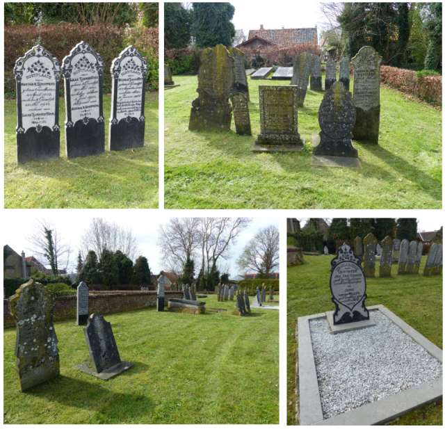
The cemetery used to be very densely filled with tombstones. Of these, a remnant remains. That which remains is in good condition. There were also many recently known beneficiaries. The grave monuments are a good representation of nineteenth- and early twentieth-century grave culture in Friesland. Most of them consist of hardstone. Of particular interest from the twentieth century are the grave monuments made of granite. The cemetery has a fine amount of tombstones which, by their design, symbolism, material or by the persons mentioned, are of importance for the history of Gorredijk.